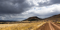
British Columbia @en

now browsing by category


Back from canada to the US !

Bad weather pursuing me, I chose the option of heading south in search of better weather…
 
 
1. It’s really larger than VLV !
 
_DSC3781b
 
 
For the record, the gross weight of the monster reached 844’600 pounds!!! Two-stroke engine of 12 cylinders, each 645 cubic inches, and 2,500 horses to move the monster, the numbers are just unimaginable. Each tire weighs 6 tons alone – there are 10 of those! – with a diameter of 11 feet 4 inches, definitely higher than VLV!
 
 
2. These trucks work in the huge open pit copper mine in Logan Lake.
 
_DSC3783b
 
 
3. The processed ore is transported by train to Vancouver harbour.
 
_DSC3787b
 
 
4. Olong the road, an abandoned church in Pokhaist.
 
_DSC3788b
 
 
5. In Spences Bridge, there is also this workshop for sale, … 😉
 
_DSC3789b
 
 
6. … and also, on the other side of the river, this outdoor theater of the Indian reservation that I found quite aesthetic.
 
_DSC3790b
 
 
7. Another church…
 
_DSC3795b
 
 
That’s it for Canada who reserved me a lot of moisture in this season. I then recrossed in the US with a little story. At the border, I got an agriculture service check and as I had forgotten three logs of firewood in the back box of VLV, the inspector sent me crossing the Canadian Customs again by foot with the three logs that I had to let on the Canadian Parking (import of untreated wood is prohibited). In short, it made me smile… 🙂
 
The weather was not better on the coast of Washington, so I went through Seattle without stopping and headed to the East to find better weather behind the mountains.
 
 
8. By late afternoon, unexpected clearing let me see the impressive Mount Rainier. It is a gray volcano that last erupted barely 300 years ago.
 
_DSC3802_sb_b
 
 
9. The next day, the rain is still with me when I go down the East side of the Cascade Range. Within a few tens of kilometers, landscapes change from a very wet climate to semi-desert lands, pretty amazing. Here halfway, it’s a typical Mediterranean climate with small oak trees that show a full range of autumn colors.
 
_DSC3811b
 
 
10. Arrived late at night, I woke up on the site of Palouse Falls.
 
_DSC3822_sb2_b
 
 
11. Light was difficult but I went anyway down the canyon…
 
_DSC3832_sb2_b
 
 
12 … before to go up again for this view from above.
 
_DSC3841b
 
 
13. New descent on the other side this time to try to see the falls from below, which I managed after many unsuccessful attempts to find a way that allows me to reach the bottom of the canyon.
 
_DSC3845b
 
 
14. These waterfalls are gorgious, jumping barely 200 feet of basalt.
 
_DSC3853b
 
 
15. VLV take the road towards Oregon to the South. Here an old shed…
 
_DSC3842b
 
 
16. Here, some dirt road through the hills…
 
_DSC3843b
 
 
17. Here again, one of those metal bridges that cross some rivers.
 
_DSC3855b
 
 
18. Arrived in Oregon, there is a lot of Wind mills on the plains where the wind often blows.
 
_DSC3860b
 
 
19. Il slept on a ridge with a beautiful late afternoon light on the plain.
 
_DSC3859b
 
 
I will present a few sites in Oregon in the next update! 😀


Totems and waterfalls…

The rain was still falling, I pulled to spots that I could photograph despite the low clouds and the omnipresent mist … So I made ​​a detour to discover Indian totems of Gilawox and Kispiox. Indeed, it is from this region that Indian totems are known worldwide.
 
 
1. These totems are carved from cedar logs.
 
_DSC3720b
 
 
2. They feature various symbols, characters, animals or, as here, the sun.
 
_DSC3718b
 
 
3. They had no religious significance but allowed the different tribes to distinguish themselves…
 
_DSC3719b
 
 
4. … who competed for originality.
 
_DSC3730b
 
 
5. One of the most imposing is in Kispiox.
 
_DSC3732b
 
 
6. They sometimes have additions to the main trunk, as bird beak.
 
_DSC3737b
 
 
7. A last one, to show you how they can be different.
 
_DSC3738b
 
 
8. Still in the rain- I was a little tired of it, I confess- a beautiful waterfall rushing from a glacier that I haven’t even been able to see in the clouds…
 
_DSC3745b
 
 
9. VivaLaVida riding back roads, I sometimes discover ancient tombs in the forest.
 
_DSC3748b
 
 
10. It maybe don’t look like but it’s still raining!
 
_DSC3749b
 
 
11. After six days of high humidity, I finally saw a small clearing to my camp on the shores of Bobtail Lake…
 
_DSC3750b
 
 
12. … which will gratify me with a beautiful sunset.
 
_DSC3760_sb_b
 
 
13. I take this opportunity to cook some moose meat that Hector has kindly offered me when I was in Whitehorse. Indeed, I wanted to taste that meat that cannot be bought, the regulations are very strict: they can be hunted only for own use. This meat is excellent, I would say a taste between elk and wild boar.
Thank you again Hector! 😉
 
_DSC3767b
 
 
14. Oh, I forgot to tell you. In Stewart while I was drinking coffee in the Armorlight Grocerey store, a man came eating his sandwich at my table. “Goti”, a diminutive of Gotlieb, is a Swiss guy who emigrated to Canada 37 years ago, accompanied by his wife born in Geneva. It is him who holds the grocery store and do you know what? He had Fribourg Vacherin cheese!!! I didn’t hesitate to buy some when he said that! 😀 With a piece of original Gruyere cheese also.
 
_DSC3775b
 
 
15. After six days of rain, it’s good to have some sunlight on the trail… 😉
 
_DSC3768b
 
 
16. Back roads I told you…
 
_DSC3771b
 
 
17. New detour in the Clearwater Valley to explore Helmcken Falls, well-known but extremely impressive, almost 500 feet high – as high as the fountain in Geneva if I’m not mistaken – digging this old lava plateau to form a deep canyon. Unfortunately, the rain was back…
 
_DSC3777b
 
 
Anecdote of the day. Starting again from Helmcken Falls, I thought continue up the valley to the Clearwater Lake but maneuvering, I felt the brake pedal very soft! as I was lying under VLV I discovered that one of the brake lines was broken where it attaches to the caliper, the fluid flowing on the ground. Gulp, no brakes at all in these conditions!
 
I was 35 miles away form Clearwater, it was 5 PM, My cell phone isn’t working in Canada… I decided to try to bring VLV in Clearwater without brakes..! After still have clogged the hose with a screw and a clamp around (photo taken the day after with my iPhone. Do not ask me how that’s possible, the first and back planes are sharp but the hose is blured..! They don’t stop progress at Apple!!! :-D)
 
durite
 
 
It will take me 3 hours to travel 35 miles of a small mountainous road, with downhills to over 10%. Transfer case on “low”, VLV downgraded these steephills only on engine brake, sometimes at 3 MPH in 2nd gear and low range and without touching once the brakes (I did not have those anyway … ). In Clearwater at around 21h, I lay in the driveway of a workshop that will provide me a hose in the morning and after 3 hours of work, VLV was fixed… Thanks to that workshop owner for letting me enter VLV and work sheltered from the rain. 😉
 
But it has at least allowed me to discover another brake problems. While I had replaced all the rear brakes (discs, calipers, pads) in Anchorage only 7,000 miles ago), I discovered that the inner pads are completely worn again while the outer ones are almost new. The trouble comes from the single piston calipers with slides locked by the mud of wet dirt roads. Thus, the pressure acts only on the inner pad. So I’ll have to replace them again without much delay. But I’ll try to find another caliper with pistons on each side to replace the cactual ones and solve the problem. I’ll keep you posted… 🙂
 
Other adventures of VivaLaVida to come soon.


Cassiar & Stewart Highways

Vivalavida will now wipe six days of almost continuous rain. Indeed, it is the rain season near the Pacific coast, I didn’t really realize it until now…
 
 
1. A pond in the myst…
 
_DSC3629b
 
 
Despite the weather, I went for a detour to Stewart to try to spot some of the many glaciers in the region.
 
 
2. The “Bear Glacier”, along the Stewart HWY.
 
_DSC3631b
 
 
3. The mining road VivaLaVida borrowed in the rain to climb to other glaciers. Funny, we were in Alaska again for a few tens of miles without any customs as it is a dead end! 😀
 
_DSC3636b
 
 
4. Oups, the road ends here for VLV! I continue riding the mountain bike…
 
_DSC3662b
 
 
5. I’m lucky, a brief lull allows me to see the Bereton Glacier in the fog, it’s around 16:30.
 
_DSC3641b
 
 
6. A little later, I even have some sunlight that makes wet rock shining.
 
_DSC3644b
 
 
7. The road ends at this abandoned mine…
 
_DSC3666b
 
 
Back to VLV, I turned back to hope to see the Salmon Glacier, a huge glacier in T before night falls.
 
 
8. VLV seems very small in front of the giant!
 
_DSC3673b
 
 
9. Panoramic to attempt to show you the northern branch. The thrust is so strong that ice is pushed several hundred yards over the mountain (bottom right).
 
_DSC3678_pano_b
 
 
10. A second panoramic to show the immensity of the ice flow; more than 40 miles long and about 6 miles wide for its main part!
 
_DSC3687_pano_b
 
 
I slept on site, hoping for a better light in the morning but I woke up in a dense fog. I then went back down to Stewart…
 
 
11. … here in the middle distance, behind the harbor.
 
_DSC3690b
 
 
12. Seb, if there’s too much snow this winter in Arzier, I found what you need !! With that, you won’t never remain blocked! 😉 This is a Russian car which I have not been able to understand the brand.
 
_DSC3691b
 
 
Still in the rain, I continued South with a new detour to the Nisga’a lava fields, theater of the last volcanic eruption in Canada, about 300 years ago. 2,000 Indians were killed, several villages have been swallowed up. The melt is more than 20 miles long and deflected a big river from several miles.
 
 
13. The only bright spot of the day on VivaLaVida’s way and still in the rain.
 
_DSC3692b
 
 
14. Rainy inlet the next day…
 
_DSC3694b
 
 
15. Marsesh where lichen took possession of the dead trees. Nice atmosphere, isn’t it? We could see one or two trolls showing up? 😉
 
_DSC3698b
 
 
16. Arrival at the lava beds, sometimes smooth as in the background, sometimes chaotic. They reach more than 45 feet thick in places.
 
_DSC3701b
 
 
17. Crack…
 
_DSC3703b
 
 
18. Few trees were able to grow in this young and barren rock.
 
_DSC3709b
 
 
19. A small cascade which drains a lake, also created by the lava flow.
 
_DSC3712b
 
 
20. Small rainbow as VLV continues heading South.
 
_DSC3714b
 
 
Continuation of the descent of British Columbia in the next update.


Cassiar Highway

VivaLaVida has left the Yukon and began his journey across British Columbia toward South.
 
 
1. First night in BC on the lovely little Boya Lake.
 
_DSC3520b
 
 
2. A few minutes ago, I was in this beautiful snow shower!
 
_DSC3525b
 
 
3. Best of all, as a goodbye from the Yukon on which she extends, this beautiful northern light was offered to my eyes as the full moon lit up the shores of the lake.
 
_DSC3527b
 
 
4. The Cassiar Highway isn’t in really good state and snowshowers continue the next day…
 
_DSC3534b
 
 
5. Graphism of the snow on this lake.
 
_DSC3537b
 
 
First detour to discover the valley that leads to Telegraph Creek, a samll village. This valley is the lower valley of the Stikine River, a mighty river that carves its canyon through layers of basalt before emptying into the Pacific Ocean.
 
 
6. Confluence of Tahltan and Stikine rivers, with the summer camp of Tahltan Indians. They spend three months there to catch salmons migrating upstream these rivers.
 
_DSC3607b
 
 
7. Tahltan cabins.
 
_DSC3545b
 
 
8. Almost at the end of the road, after Telegraph Creek, there is a nice small lake…
 
_DSC3554b
 
 
9. … dressed in the colors of autumn that I found back in these warmer latitudes.
 
_DSC3556b
 
 
10. The Stikine River, powerfull and gorgious…
 
_DSC3591b
 
 
11. … which flows to the Pacific, just behind the distant mountains.
 
_DSC3595b
 
 
12. It’s the high season for parades of ruffed grouse!
 
_DSC3570b
 
 
13. This guy don’t care my presence and runs to the female across the road.
 
_DSC3557b
 
 
14.Here is one of the coveted female.
 
_DSC3580b
 
 
15. The road ends here. I hoped to continue on foot but the bad weather forecast for the coming week have made ​​me give up to spend the night here and hike the next day.
 
_DSC3567b
 
 
16. He was sitting in the middle of the road and went away quietly…
 
_DSC3624b
 
 
17. VivaLaVida in the Stikine River canyon.
 
_DSC3605b
 
 
18. And to complete this update, a “snowshoe” hare whose lower legs and ears remain white all summer. This is the main food of the lynx and red fox and as its population has an unchanging cycle of ten years where it almost disappears, predators must rely on squirrels and other small rodents, seeing their population also drastically reducing. It seems that the cycle of snowshoe is from a genetic cause, in part at least…
 
_DSC3627b
 
 
So much for today! The next miles of VLV to South to come in a few days… 😉


Haines HWY and back to Alaska!

 
1. Early morning at my camp…
 
_DSC3124b
 
 
2. Cold and misty atmosphere…
 
_DSC3127b
 
 
3. … but the fall colors of the tundra remain.
 
_DSC3129b
 
 
4. Small “mirror lake”….
 
_DSC3135b
 
 
5. Last pass before to go down to Haines.
 
_DSC3136b
 
 
6. Panoramic of mountains and glaciers around.
 
_DSC3141_pano_b
 
 
And surprise down the hill: there is a custom and I end up back in Alaska! My map of this area is definitly imprecise, I’d forgotten that Haines and Skagway are on the thin strip of Alaska along the West border of British Columbia. 😀
 
 
7. I find the Pacific back or at least one of his fjords.
 
_DSC3148b
 
 
8. Haines, also along a fjord.
 
_DSC3152b
 
 
9. His small harbor houses as much fishing and pleasure boats.
 
_DSC3149b
 
 
10. Since there is no road between Haines to Skagway, VivaLaVida also took a boat to travel about 18 miles by sea! 😉
 
_DSC3154b
 
 
11. Cruise ambiance…
 
_DSC3156b
 
 
12. … while the ferry navigates to the end of the fjord.
 
_DSC3158b
 
 
Arriving in Skagway is exotic. It is a very touristy place that keeps memory of the gold rush. It was here that the pioneers landed, then crossed the White Pass by walk before to build boats that took them down to Dawson City by the Yukon River.
 
 
13. Main Street with, in succession, a large cruise ship hosting likely thousands of tourists.
 
_DSC3160b
 
 
14. Most buildings date from the late 19th century…
 
_DSC3159b
 
 
15. … and the atmosphere is a bit of another time.
 
_DSC3161b
 
 
16. I leave Skagway in late afternoon and makes me to the White Pass, about twenty miles North.
 
_DSC3169b
 
 
17. These granite mountains eroded by glaciers and dotted with small lakes really makes me think about some landscape of Norway.
 
_DSC3179b
 
 
18. I decide to camp between the Alaskan and Canadian borders.
 
_DSC3176b
 
 
19. Last colors on the mountains…
 
_DSC3184b
 
 
Second return to Canada in less than a week to come in the next update! 😀


Jasper National Park & South Alaska Highway

Continuing my journey in Canadian Rockies.
 
 
1. Going up the Maligne Valley in Jasper National Park.
 
_DSC9715b
 
 
2. Allong the road, meeting with a small group of big horn sheeps and calfs.
 
_DSC9700b
 
 
3. Likely only a few weeks old…
 
_DSC9704b
 
 
4. Maligne River.
 
_DSC9713b
 
 
5. And here are some variations on the beautiful Maligne Lake. In the rain first…
 
_DSC9710b
 
 
6. A gap emerges in the clouds.
 
_DSC9718b
 
 
7. Some light now…
 
_DSC9722b
 
 
8. … then a new shower arriving.
 
_DSC9728b
 
 
That concludes this series on the Rocky Mountains, for now at least.
VivaLaVida continued on the road to the north and entered the Alaska Highway in Dawson Creek, British Columbia. This highway was built in the forties and is completely paved since aboute ten years. It connects Dawson Creek to Anchorage, more than 1,700 miles away.
 
 
9. A wooden curved bridge on Old Alaskan Highway.
 
_DSC9732b
 
 
10. Great construction!
 
_DSC9746b
 
 
11. Nice Spring Flower Lake in Stone Mountain Provincial Park.
 
_DSC9751_pano_b
 
 
12. I attended to ice sheets driven into the river that flows from Lake crashing on the rocks in a noise like a thousand of bells chime … Too bad I can not make you listen at… 🙂
 
_DSC9758b
 
 
13. Camp along McDonald Creek. It’s 11 PM, the days get longer as I move north…
 
_DSC9767b
 
 
14. A bird I don’t remember the English name. Difficult to approach, it took me quite a few attempts to achieve…
 
_DSC9770b
 
 
15. Muncho Lake along the Alaska Highway.
 
_DSC9774b
 
 
16. Along the trail to hot springs, in a clearing, I first saw this male forest bison, a subspecies endemic to Canada that has adapted to life in the forest.
 
_DSC9782b
 
 
17. On my guard because these behemoths have bad reputation, I discovered in a meadow a little further a herd with calfs of the year.
 
_DSC9778b
 
 
18. Marsh created by the sulfur springs that flow there. This water creates a unique ecosystem, with small fishes that can live only in the hot water. It is also very frequented by mammals which appreciate this highly mineralized water instead.
 
_DSC9786b
 
 
That ends my journey across British Columbia. I’ll take you soon discover a some of the Yukon… 😉