


Pass of Valbelle
Still on our way back home, we pass by chance near the “Demoiselles coiffees”, some hoodoos on south shore of the Serre-Poncon lake. 1. A short hike takes us near these always impressive concretions. 2. The site is evolving fast. Its configuration has changed aRead More…
Haute-Ubaye
Coming down from Larche Pass (Colle della Maddalena), we go discover the Lautanier valley. 1. Fall colors are everywhere. 2. Hiking up the valley. 3. Meander. 4. A hiker on the bridge. 😉 5. Ubayette RiverRead More…
Lake Meja
The next morning, we set off on a hike to explore Lake Meja despite the poor weather.. 1. Our camp going up towards the small pass which overlooks us. 2. We see a few ibex near the pass. 3. Mountains appear andRead More…
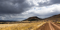
Maira Stura
As announced, we continued South hoping to be able to access the Maira Stura trail which was closed during our last visit in summer. 1. Chapel of San Salvatore, driving up the Val Maira. 2. Village of Macra, in the same valley. Read More…
Fall holiday : Lake Lauson
For the second week of Emile’s vacation, we went to discover new alpine spots. 1. Sunset et our first boondocking spot, near Sansicario. 2. Herd going up towards Sestriere. 3. Going down the valley of Cluson river. 4. OnRead More…
Waterfalls in Jura Mountains…
In mid-October, in Emile’s absence, I went for a little trip to the Hérisson waterfalls, in the neighboring French Jura. 1. Gour Bleu waterfall, horizontal version. 2. Gour Bleu waterfall, vertical version. 3. Mushrooms… 4. Bubbling undergrowth. Read More…
Return through Lozère, the Cévennes and the Ardèche
It’s time to go home as Emile is flying to America in three days with his mother.. 1. Small village not far from our camp. 2. Another one, a little further. 3. Pastures of the Lozère highlands. 4. IRead More…
Highlands of Lozère
Coming back from Spain, we cross France by small roads, discovering some spots identified during previous research. We arrive in Gorges du Tarn and go up to a first causse (kind of of high plateau) by a very small road. It leads us to a trailhead to discover severalRead More…
Rougier de Camarès and Millau bridge
We continue our return journey with several detours… 1. Pretty village of Saint-Sernin-sur-Rance on our road to Aveyron. 2. We arrive in Camares at the end of the afternoon… 3. … and we go discover its “rougier”. 4. ItRead More…
Back in France…
As announced in the previous post, we are back in France, on the northern slopes of the Pyrenees. We go to discover Navarrenx, a pretty fortified little town about 25 miles West of Pau. 1. One of the entrances of the city. 2. Patrol path…Read More…
 D5 Creation