


Merry Christmas
The time has come to wish you all a Merry Christmas! 😀 At the time I’m writing these lines to be published in two days, I do not know yet where VivaLaVida is gonna lead me for Christmas night… 😉 I take the opportunity to announce aRead More…
McKay Flat & Reds Canyon
1. The night was clear and at this altitude, the frost covers everything including VivaLaVida. 2. In exposed areas, ice crystals are huge! 3. Even cactus appear to wear Christmas dress… 😉 4. This old juniper trunk looks almost likeRead More…
South San Rafael Swell
Out of my hike in the slot canyons, I saw a sign “Muddy Creek”. I thus followed the trail south and had the good surprise to find a quite large area of “bentonite”, this kind of clay that I also found at the Painted Hill in Oregon. 1.Read More…
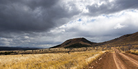
San Rafael Swell
Continuation of discovering this region less known and yet not far from Moab. 1. VivaLaVida on a little-used trail that circumvents Temple Mountain. 2. They are many old uranium mines in the area. 3. They are of course closed. Read More…
Ruins and canyons
At a small meeting with Tom, aka Zeta on Sportsmobile forum, he advised me to visit the Hovenweep National Monument, a site where are grouped different Anasazi ruins. When I went there, it was raining but I still visited seven different sites. 1. The Twin Towers, on theRead More…
Sandstone around Moab
Leaving the Beef Basin, I had the good surprise to find a message from Hans, a Swiss who lives here with his wife Madeleine for 35 years. I was greeted like a king by this adorable couple, not forgeting to specify that Madeleine is fine cooker. 😉 They explainedRead More…
Still in Beef Basin…
1. It begins with a blurry picture! 😉 Just to show that it was chilly that morning… While I was getting ready to break camp, I noticed a young stag who seemed a little nervous. I decided to approach it to try to photograph it.Read More…
The journey map is available again!
Thanks to Christine that noticed the issue, it should be fixed now. 😉
Ruins in Beef Basin.
Despite snow announced in the mountains, VivaLaVida headed south of Moab in the Beef Basin, an area which was the wintering place for Atabascan Indians between 2,000 and 700 years ago. It contains many relics like ruins and petroglyphs or petrographs. 1. Some tracks that VLV borrows areRead More…
On the left bank of the Colorado…
Near the end of the White Rim, I hiked to Fort Bottom, in the middle of a meander of the Green River. 1. Remains the “cabin” on a river bank. It is almost 200 years old and housed tuberculosis patients who were sent here to end their days…Read More…
 D5 Creation