


Picos de Europa (continued) and back towards East.
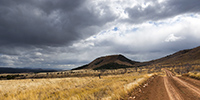
We go up the valley towards Sotres and leave the road on the right to discover a trail which climbs to almost 6,000 feet above sea level. 1. Alpine pasture at the bottom of the valley, before the climb. 2. As VivaLaVida gains altitude, theRead More…
Somiedo National Park and Picos de Europa
After traveling along the coast of Asturias, we head South to discover the Somiedo National Park, in the “valley of lakes”. 1. Houses and granaries typical of this region. 2. After spending a night in a small mountain campground in Valle de Lago, we setRead More…
Incursion into Galicia and return to Asturias
It was one of the spots I wanted to discover for a long time: Praia de Catedrais or “Beach of the Cathedrals”, in Galicia, about ten kilometers from the border with Asturias. A spot that has become extremely touristy since it was published hundreds of times on Instagram, soRead More…
Cantabrian coast and Asturias
So we continue the discovery of the coast now in Cantabria. We had already stopped near Santander last year and we go to discover another spectacular coastal spot very close by. 1. Arrival on site. 2. Laminated rock characteristic of the region. Read More…
Spanish Basque country
Wanting to discover the Guggenheim Museum building in Bilbao, we drive along the Basque coast. 1. Stop in Ondarroa to discover this pretty little coastal town. 2. Its marina at the mouth of the river. 3. Back street… Read More…
A somewhat thwarted start to the summer holidays…
After taking VivaLaVida out of its winter quarters by carrying out a major service, replacing the steering ball joints and some other maintenance work, Emile and I set off again on board for a three-week holiday heading to Galicia, which we hadn’t discovered last year. But after barelyRead More…
Way home and laste gateaway of 2023
1. We find a place to sleep in a beautiful forest. 2. In the rain, this forest is beautiful. 3. Dinner. 4. On the way back, we stop at the Cascade des Tuffes. 5. Then we go discover the Herisson Waterfalls. 6. Upper waterfall. 7. Beautiful river. 8. A fewRead More…
Getaway to the Loire Valley
Having received a stay in a Lodge at the zoo of La Flèche as my 60th Birthday present, we went there during the fall holidays. On the way back, I took the opportunity to show Emile some of the Loire Valley castles. 1. Boondocking along the Cher…Read More…
Jura outing
After the start of the school year, we went to enjoy a beautiful sunset over the Jura ridges. 1. Overlooking Chapelle-des-Bois. 2. The sky isn’t free of clouds. 3. … but it seems the sun will pass below. 4.Read More…
Way home…
1. Last boondocking with view on the ocean, not far from Bilbao, while it is raining… 2. Starter with local products! 3. Emile’s happy! 4. Quietness… 5. The rain stops, giving way to a few colorsRead More…
 D5 Creation