


Nahanni Range (still in Yukon)
Discover of the second mining road built to access the Canjum Mine, another tungsten mine still active. The Nahanni Range Road, the road that crosses the mountain range of the same name, is much better maintained than the North Canol Road since trucks are borrowing it regularly to supply theRead More…
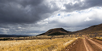
North Canol Road (2)
Once past the border of the two provinces, the road divides into two “dead ends”: one leads to Maclung Mine, 9 miles away, the other continues to the northeast to a wildlife management station, some 10 miles along the Canol Heritage Trail (the old trail I mentioned in the previousRead More…
Robert Campbell HWY & North Canol Road
Finally, I stayed five days in Whitehorse. First to support a little bit Sarah installing an additional luggage rack on the front wheel of her bike Hercules which will carry the additional stuff that may be imposed by the Canadian winter, partly to prepare the latest update your recently readRead More…
Sud Yukon
1. Up early to enjoy the first sunrays, quite rare however… 2. Some lakes empty into others in tumultuous torrents. 3. As I head to Carcross, fall colors are vibrant again. 4. I make several “photo stop”… Read More…
Haines HWY and back to Alaska!
1. Early morning at my camp… 2. Cold and misty atmosphere… 3. … but the fall colors of the tundra remain. 4. Small “mirror lake”…. 5. Last pass before to go down to Haines. Read More…
Back in Canada!
So is VivaLaVida back in Canada. 1. Short stop at Beaver Creek, the most western inhabited place in Canada. The church is funny. 2. I decide to head to Haines along Kluane National Park and the lake of the same name. Read More…
Last days in Alaska…
As I was writing the last update, I left you in Anchorage without still knowing where VivaLaVida would then head as I wrote the last article. After some cleaning and laundry tasks, a small weather window seemed to open up to Eastern Alaska where I had spotted a fewRead More…
Going back South of Alaska
Before quietly thinking about joining back Anchorage where Mino will take his plane, we still made two beautiful hikes. 1. I initiate Mino to river crossings! This one was only about 32°F. 2. Caribou migration southward began, we see several made fearful by the hinting season opened since almost twoRead More…
Brooke Range and arctic tundra
We continue farer northward… 1. Nolan valley, a side valley accessible by a really muddy small mining road . 2. At this altitude, the marshes are still not frozen. 3. I found the Brooke Range that bars northern Alaska back. Read More…
Richardson & Dalton Highways
Continuing our journey northward, we cross the Alaska Range covered with fresh snow. 1. Exploring a side valley, not far from our camp. 2. The Richardson Highway passes through high mountains with difficult access. 3. Scree dusted with snow… Read More…
 D5 Creation